


Why This Ha Giang 5-Day Tour Is Different
Most people who come to Ha Giang have heard about the loop. They ride the same passes, photograph the same viewpoints, sleep in the same guesthouses in Dong Van. And it's beautiful — genuinely. But there's a part of Ha Giang that doesn't appear on any tourist map, that most loop riders never find, and that most travellers only discover they've missed after they've already left.
This Ha Giang 5-day tour starts where standard Ha Giang tours don't go: the rice terraces of Hoang Su Phi, where Red Dao and Nung farmers have been working the same mountain slopes for generations. From there it moves into the highland provinces, up to the summit of Chieu Lau Thi at 2,402m, through village homestays that are genuine family homes — not guesthouses with ethnic decor. Then it completes the full northern circuit through the Dong Van Geopark, Ma Pi Leng Pass, and the hidden valley of Du Gia before returning quietly to Ha Giang City.
This is the only Ha Giang trekking tour that begins in Hoang Su Phi and finishes with the complete Geopark loop — no compromises. The first two days focus entirely on the landscape and communities that riders on the standard loop never reach. Days three through five cover the full Dong Van circuit: Dong Van, Ma Pi Leng Pass, Meo Vac, Quan Ba Heaven Gate, and the peaceful Du Gia valley finish. Five days. Two completely different worlds of Ha Giang. Nothing left out.
The tour departs daily from Ha Giang City and returns to Ha Giang City on Day 5 afternoon — easy to connect with an overnight bus from Hanoi in either direction. Your guide has lived in Ha Giang his whole life. He has walked these trails and ridden this loop more times than he can count. That local knowledge is not something you can buy on a tourist app. It's the difference between a good trip and an unforgettable one.
Is This Ha Giang Tour Right for You?
An honest look at who gets the most from this 5-day Hoang Su Phi trekking and Geopark loop tour — and who might be better suited to a different program.
-
🥾Trekkers who want the full picture — this is a genuine Hoang Su Phi trekking experience combined with a complete Geopark loop. Not a walk between viewpoints. Not a loop with a single village stop. Both worlds at once.
-
🟕️Travelers who care about ethnic culture — four distinct communities in five days. Red Dao, Nung, Tay, Hmong. You won’t just pass through. You’ll sleep in their homes, eat at their tables, and walk through their working farmland.
-
📸Photographers & nature lovers — Hoang Su Phi rice terraces at their most dramatic, Chieu Lau Thi summit views, the turquoise Nho Que River from Ma Pi Leng. Every single day delivers a completely different visual world.
-
🌏Off-the-beaten-path travelers — very few Western tourists reach Hoang Su Phi at all. Even fewer combine it with the Dong Van Geopark loop. This is off the beaten path Vietnam without sacrificing any of the iconic highlights.
-
👫Couples & solo travelers — small group, max 10 people, genuine village homestays. The kind of trip that creates memories you compare everything else against.
-
🏨Luxury-only travelers — homestays in Red Dao and Nung villages are clean, safe, and welcoming. But they are not boutique hotels. The magic is in the simplicity. If thread count is a deal-breaker, this probably isn’t your tour.
-
🌀Severe motion sensitivity — the road sections on Days 3–5 include the Ma Pi Leng Pass and other highland switchbacks. Medication helps, but discuss this with us before booking if mountain roads are a serious issue.
-
🛋️Zero-activity travelers — the Chieu Lau Thi summit hike on Day 2 is a full mountain day, rated 7/10 difficulty. There’s no vehicle shortcut to the top. If a full summit hike isn’t for you, let us know and we can adjust.
-
📶Those who need constant connectivity — signal is very limited or absent in Hoang Su Phi and the highland villages. A few days offline. Most people come to see this as the best part of the trip.
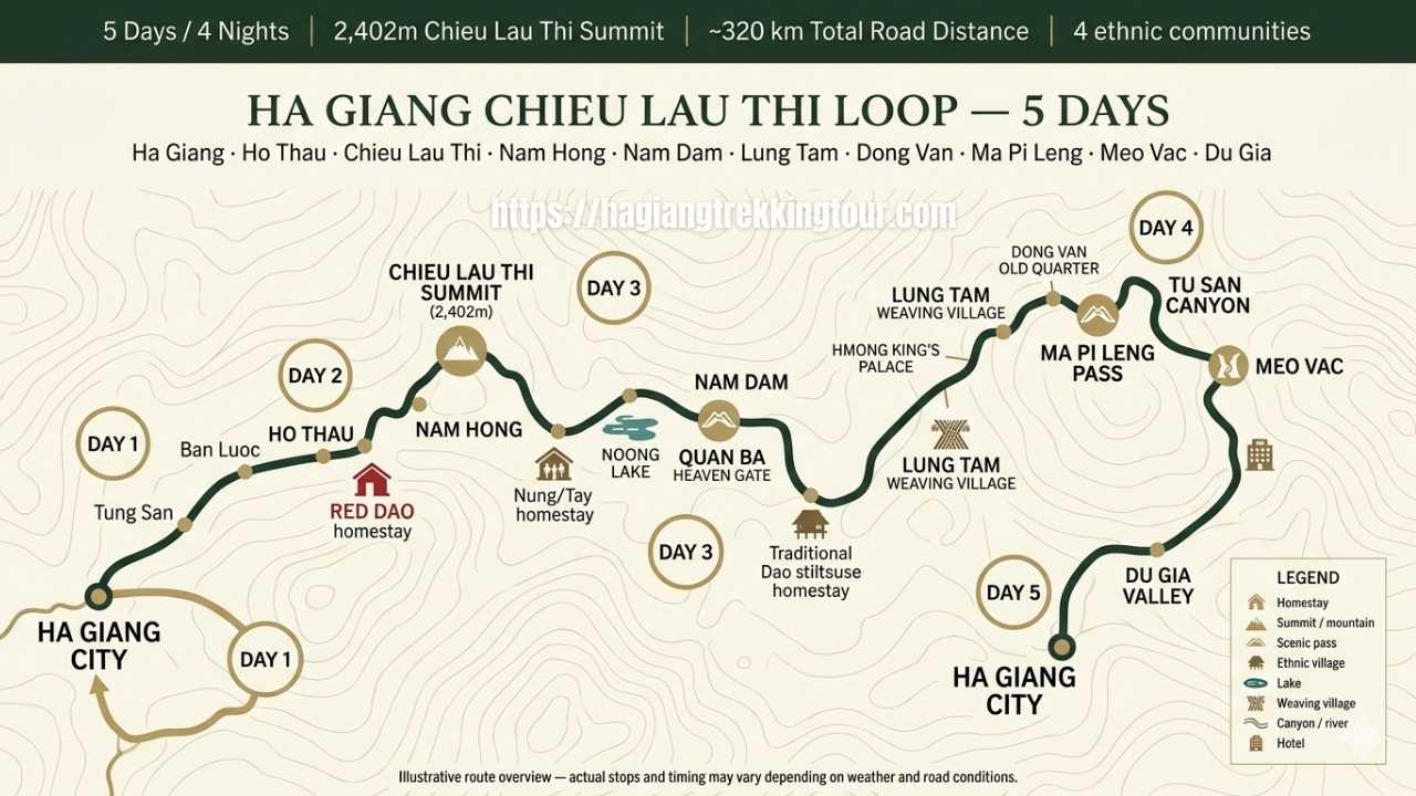
5-Day Ha Giang Itinerary: Hoang Su Phi Trek + Dong Van Geopark Loop
- Scenic drive through Tung San Heaven Gate
- Rice terraces & ethnic villages en route
- Lunch in Tung San town
- Sunset in Ho Thau village
- Chieu Lau Thi summit (2,402m)
- Panoramic highland views
- Nung ethnic culture, Nam Khoa
- Arrive beautiful Nam Hong village
- Morning visit: Noong Lake
- Quan Ba Heaven Gate & Twin Mountains
- Arrive Nam Dam, Dao stilt village
- Hmong weaving demo, Lung Tam
- Hmong King's Palace & Dong Van Old Quarter
- Ma Pi Leng Pass — Tu San Canyon view
- Arrive Meo Vac for dinner
- Scenic ride to Du Gia valley
- Lunch in Tay ethnic village
- Return Ha Giang City ~afternoon
- Tour ends at Dong Van Tour office
Ha Giang City → Tung San Heaven Gate → Hoang Su Phi → Ban Luoc → Ho Thau · First Day in Hoang Su Phi
Most people in Ha Giang City have never been to Hoang Su Phi. Most Ha Giang tour operators haven't either. It sits to the southwest, away from the main loop routes, and getting there requires the kind of commitment that filters out the casual day-trippers. That's exactly what makes it worth going.
You leave Ha Giang City early morning and the landscape begins changing almost immediately. Within the first hour, the road starts climbing through valleys that barely appear on tourist maps — forested ridgelines, small streams running under wooden bridges, women in Red Dao embroidered jackets walking the roadside. The drive passes through Tung San Heaven Gate, a mountain pass that frames the descent into Hoang Su Phi with a view that makes most passengers instinctively reach for their cameras.
Lunch is in Tung San, the district town of Hoang Su Phi. Nothing fancy — a local restaurant with generous portions and a view of the valley that most visitors only see from car windows while driving past. After lunch the road winds further into the highlands toward Ban Luoc, a stretch of Hoang Su Phi famous for having some of the most dramatically layered terraced rice fields in all of northern Vietnam.
The terraces here were carved by Red Dao and La Chi farmers over centuries, without machinery, following the natural contours of the mountain. Depending on the season, you'll see them bright green with new rice, golden yellow at harvest, or flooded silver in the rainy season. Every version is a different spectacle.
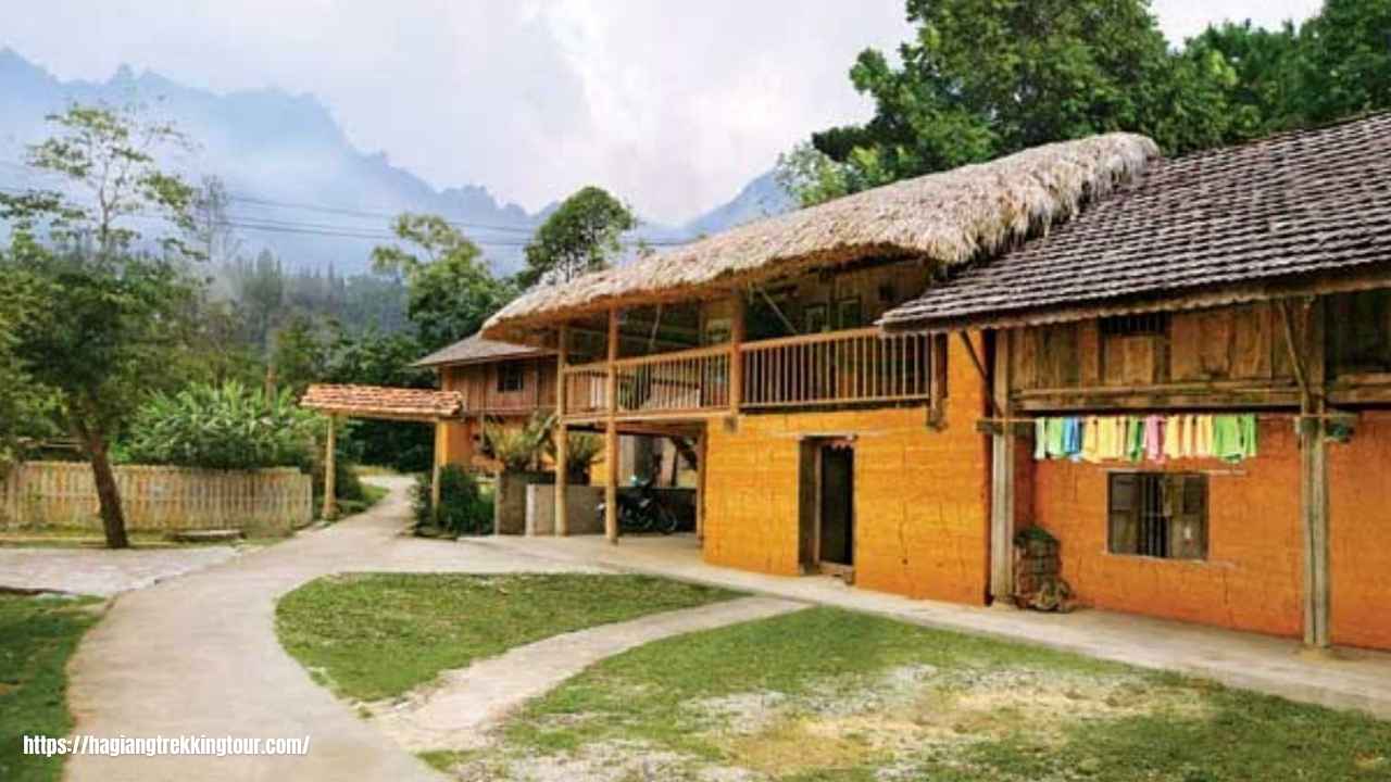
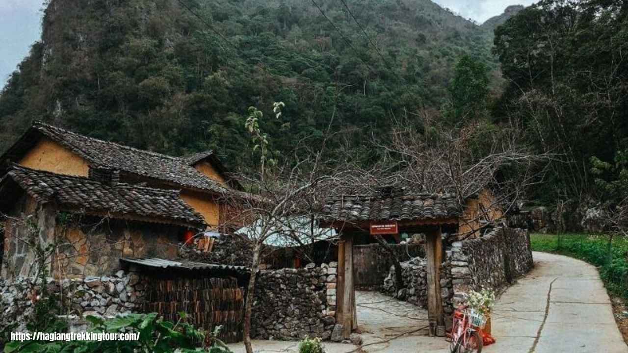
Late afternoon you arrive at Ho Thau village — a Red Dao community in the upper Hoang Su Phi highlands. The light at this hour falls sideways across the terrace walls. The village is quiet in the way mountain villages are quiet: no traffic, no music, just the sound of the land. Your homestay family here has been hosting guests for years. The welcome is matter-of-fact and genuine, which is better than theatrical.
Dinner is home-cooked on a wood fire, vegetables from the terrace garden, chicken or pork from the village. Corn liquor will be offered. It's polite to try at least a small pour.
Ho Thau → Chieu Lau Thi Summit (2,402m) → Nam Khoa → Nam Hong · The Summit Day
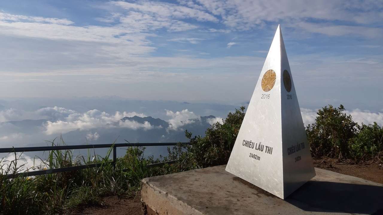
Breakfast at the homestay before 7am. Your guide will go through the trail with you over the meal: the route, the terrain, what to expect at the summit, how long each section takes. This is the kind of preparation that turns a hard hike into a manageable one.
Chieu Lau Thi is Ha Giang province's highest mountain at 2,402 metres. The trail starts from Ho Thau and climbs through dense sub-tropical forest before breaking into open ridge terrain. The summit view covers a vast expanse of the northern highlands — clouds below on clear mornings, layers of blue ridgeline all the way to the Chinese border.
The first two hours of the hike are through old-growth forest — ferns, moss-covered rocks, the occasional wild orchid. The air is cool and damp. The canopy filters the light into something photogenic even when you're not trying. Your guide sets a pace that allows for stops, photographs, and breathing.
Above the treeline, the terrain opens onto exposed ridge that requires some careful footing but no technical climbing. The last stretch to the summit is steep but short. Most people in reasonable fitness complete the summit approach in 3–4 hours. The descent is faster.
After descending and a trail-side lunch, the afternoon moves into the Nung ethnic community of Nam Khoa. The Nung are one of Ha Giang's lesser-known minority groups outside the province — their villages are compact, their textiles distinctive, their relationship with the land specific to these mid-elevation slopes. Your guide introduces you to the community naturally, without staging.
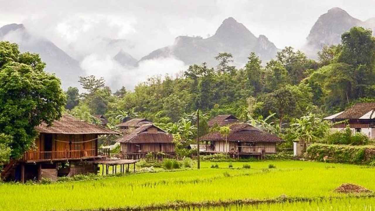
By late afternoon you reach Nam Hong village — widely considered one of the most scenic villages in Hoang Su Phi. The valley opens here, the terraces are wide and well-maintained, and the homestay family you'll stay with tonight is Tay — a completely different ethnic group from yesterday's Red Dao hosts. Different food, different architecture, different evening energy.
Nam Hong → Noong Lake → Quan Ba Heaven Gate → Nam Dam · Heading North
Day 3 is a recovery day for the legs and a full day for the eyes. You leave Nam Hong after breakfast and the drive begins moving northeast, back toward Ha Giang and then north into the Geopark region. The landscape changes noticeably as elevation increases — the lush terraced farming country of Hoang Su Phi gives way to karst limestone formations that start appearing in the middle distance.
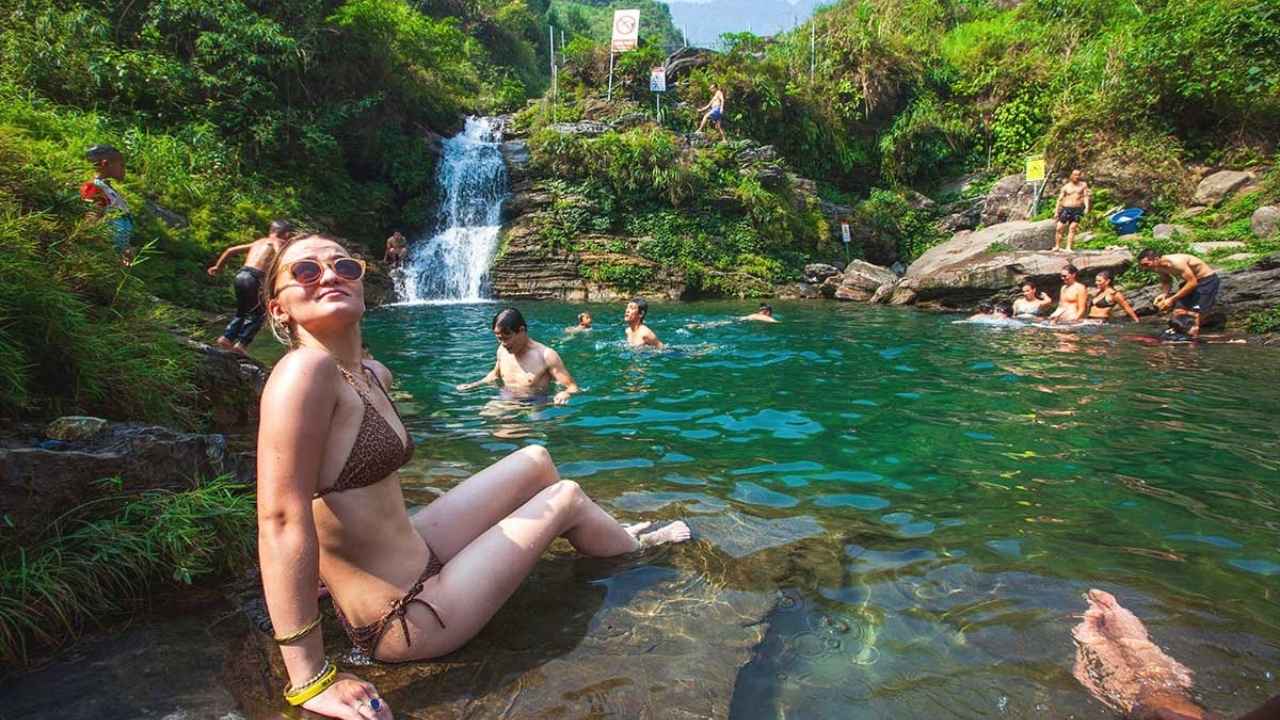
The first stop is Noong Lake — a high-altitude lake sitting in a mountain basin with no development around it. It's quiet, green, and completely unlike the dramatic scenery that comes later on the loop. A short walk, some time by the water, and then back on the road.
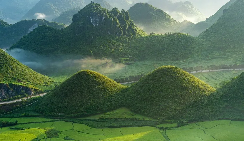
The road ascends to Quan Ba Heaven Gate — a mountain pass that frames the valley below through a natural limestone archway. From the viewpoint, the famous Quan Ba Twin Mountains come into view: two perfectly round karst peaks rising from the valley floor. The legend says a fairy left them behind when she returned to the sky. The geology says they're isolated remnant towers. Either way, they're extraordinary, and this is one of the most photographed views in all of northern Vietnam.
Lunch is somewhere around Quan Ba — a local restaurant, proper food, time to rest before the afternoon drive.
The final destination is Nam Dam village — a traditional Dao community in the outer Geopark region that very few itineraries include. The village sits in a narrow valley with forested hills on both sides. The stilt houses are genuine traditional architecture — wood, bamboo, elevated floors, open cooking areas. Your guide will introduce you to the homestay family and translate the evening conversation.
Dinner is home-cooked. The evening is unhurried. Tomorrow is the biggest day of the tour, so rest well.
Nam Dam → Lung Tam → Dong Van → Ma Pi Leng Pass → Meo Vac · The Legendary Day
The morning opens with a stop at Lung Tam village, where Hmong women have been producing traditional hemp fabric for generations. This is a genuine working craft — not a tourist demonstration centre. The looms are in the houses, the women work while watching their children, and your guide can explain the full process from plant to finished cloth. It's an unhurried stop that sets the cultural context for the rest of the day perfectly.
The Hmong King's Palace — known in Vietnamese as Dinh Vua Meo — is the former residence of Vuong Chi Sinh, the Hmong king who ruled these mountain regions in the early 20th century under both French colonial and Chinese influence. The palace is a remarkable piece of architecture: Chinese design elements blended with Hmong traditional building methods, set into a mountainside above Dong Van. The rooms are preserved, the history is complex, and your guide's interpretation of it is far more honest than the official information boards.
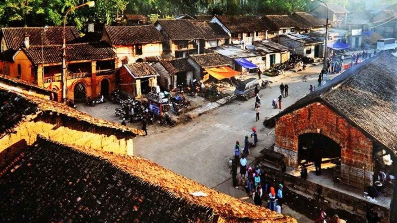
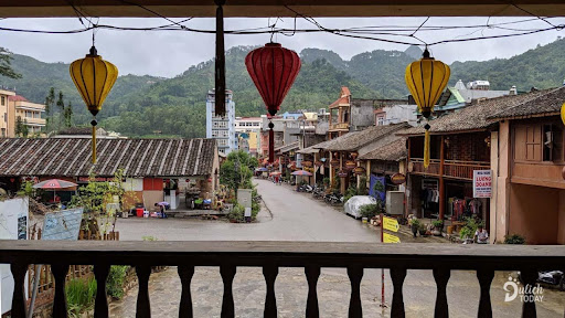
From there, a short drive to the Dong Van Old Quarter — a preserved colonial-era market street at the foot of the karst plateau. Stone buildings, wooden shop fronts, a Sunday market that draws Hmong, Lo Lo, and Nung communities from the surrounding highlands. Even midweek, the town has a distinct atmosphere that most places in Ha Giang don't have.
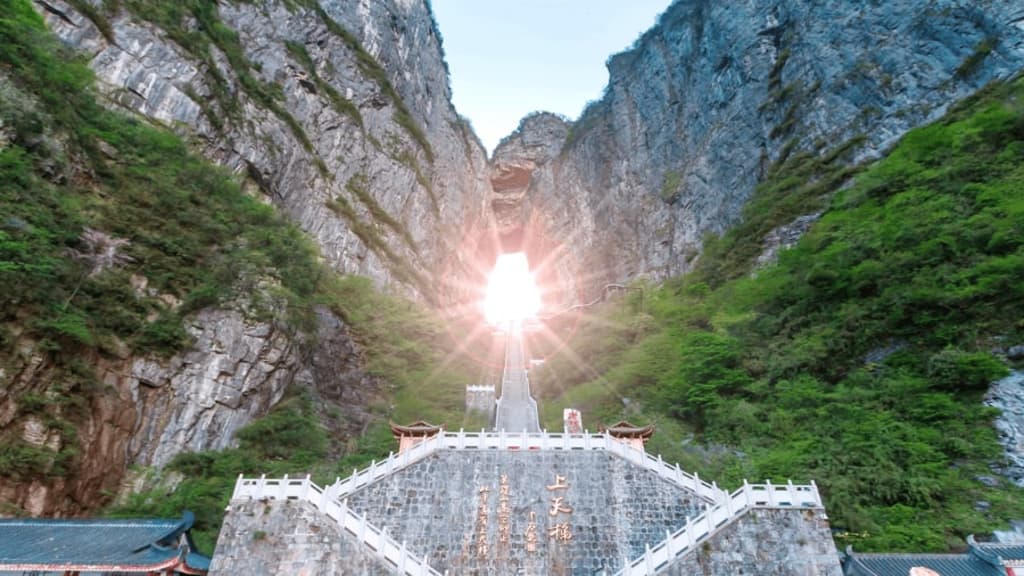
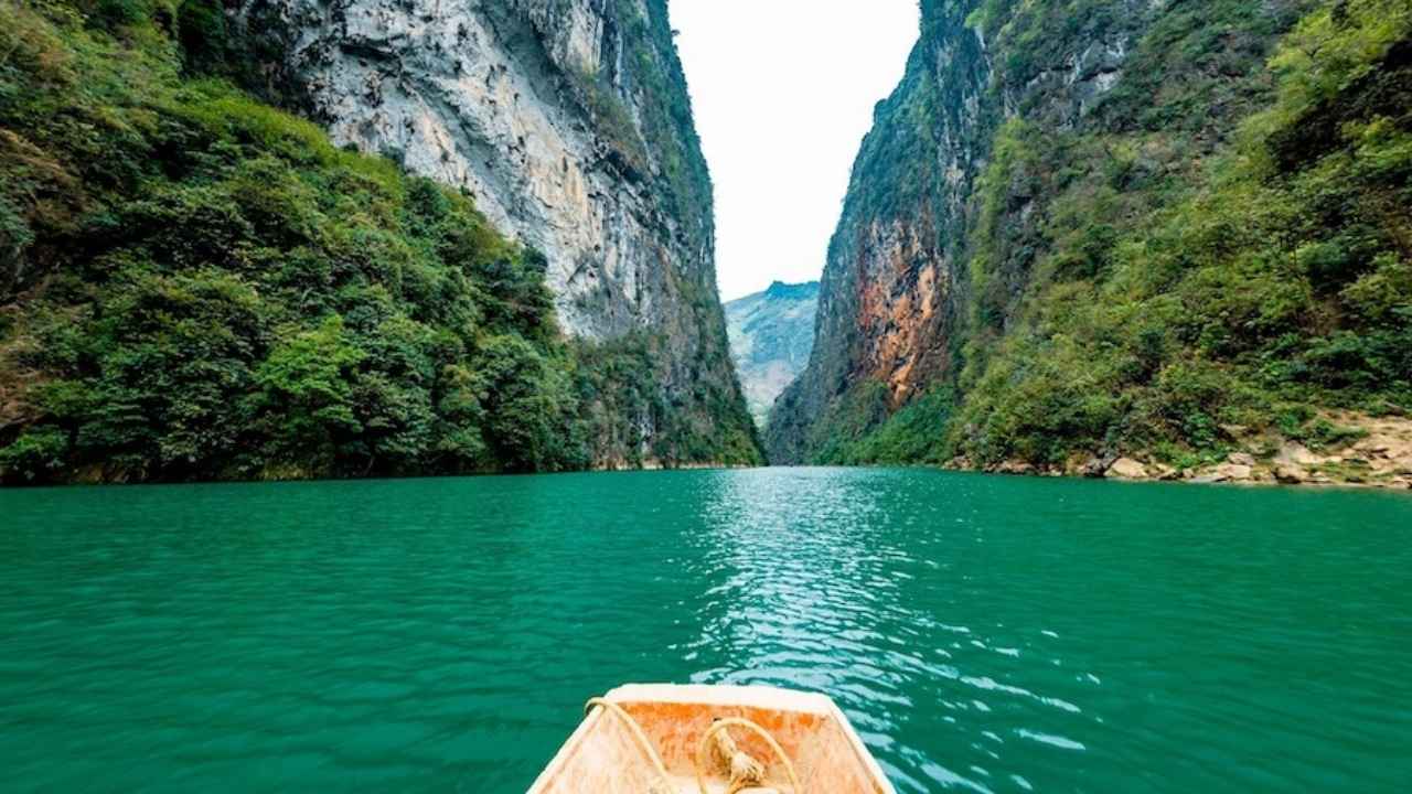
Nothing in this itinerary — and arguably nothing in Vietnam — prepares you adequately for Ma Pi Leng Pass. This is a 20-kilometre road carved by hand through sheer limestone cliffs over eleven years by 1,300 volunteers without a single piece of motorised equipment. In Hmong language, Ma Pi Leng means horse's chin — the near-vertical cliff face the road clings to.
The Tu San Canyon viewpoint reveals the Nho Que River 200 metres below, running a colour of turquoise that looks impossible until you see it. The colour is real — it comes from the limestone mineral content of the karst. On clear afternoons, this is where the tour group goes completely silent at the same moment.
You arrive in Meo Vac by late afternoon — a market town in a deep basin surrounded by the Geopark's most dramatic formations. The hotel here has proper showers and real beds. You've earned them.
Meo Vac → Du Gia Valley → Ha Giang City · The Peaceful Finale
The final morning opens unhurried. Breakfast in Meo Vac, then the road south toward Ha Giang City. The route passes through the outer edge of the Geopark — the limestone formations gradually giving way to greener, more forested terrain as the altitude drops. It's a beautiful ride that most people on the standard loop never make because they're heading back the other way.
The destination is Du Gia — a Tay ethnic community in a valley that feels deliberately hidden. The river runs clean and fast through the bottom of it. The rice paddies are flat and productive. The pace of life is noticeably slower than the Geopark towns of the previous two days.
Lunch is hosted in a Tay family home in Du Gia — a long table, family-style dishes, the sound of the river outside. The Tay are Ha Giang's valley people: their food is milder than the highland Dao and Hmong cooking you've had over the past four days, their houses are built differently, and their relationship with water rather than mountain defines their aesthetic. It's a fitting cultural finish to a tour that has moved through four completely different ethnic worlds.
After lunch, the road winds back north to Ha Giang City. The tour concludes at the Dong Van Tour office, where your guide can assist with luggage storage, onward bus bookings, or any other arrangements. Most guests take the overnight bus back to Hanoi the same evening. A few decide to add a night in Ha Giang. Either decision is fine — it's easier to make after a proper shower.
Programs and exact schedules may adjust for weather, road conditions, or seasonal factors. The Chieu Lau Thi summit hike (Day 2) is weather-dependent — your guide will assess conditions the evening before. Your guide will communicate any changes the evening prior to each day.
What's Included & Excluded
✅ Included
- ✓Transportation — motorbike, Easyrider, or private car (with fuel) throughout all 5 days
- ✓4 nights accommodation — 3 village homestays (Red Dao, Nung/Tay, Dao) + 1 hotel in Meo Vac
- ✓All meals — breakfast, lunch & dinner every day (local Vietnamese and ethnic cuisine)
- ✓All entrance fees — Hmong King's Palace and all cultural / sightseeing sites
- ✓Local English-speaking guide throughout all 5 days — deep local knowledge
- ✓Drinking water — 1 bottle per person per day
- ✓Cultural experiences — Hmong hemp weaving demo, ethnic village walks, homestay interactions
- ✓Trekking & hiking — Chieu Lau Thi mountain summit hike
- ✓24/7 local office support in Ha Giang City
❌ Not Included
- ✗Personal expenses (souvenirs, laundry, etc.)
- ✗Tips for guide/driver (optional but appreciated)
- ✗Alcoholic beverages (except welcome local corn liquor)
- ✗Travel insurance (strongly recommended)
- ✗Travel Permit: required permit for foreign travelers in border areas (Dong Van region)
- ✗Transportation to/from Ha Giang City (can be arranged on request)
Practical Information
| Departs from | Ha Giang City · exact pick-up time confirmed by WhatsApp the evening before |
| Returns to | Ha Giang City, Day 5 afternoon — most guests take the overnight bus back to Hanoi the same evening |
| Day 2 trekking | Chieu Lau Thi summit ~2,402m — Level 7/10 Full mountain hike through forest and ridge terrain — trekking shoes and layers essential |
| Group size | Small group — max 10 travelers · private tour available on request |
| Homestays | Night 1: Red Dao homestay, Ho Thau · Night 2: Nung/Tay stilt house, Nam Hong · Night 3: Dao stilt house, Nam Dam · Night 4: hotel, Meo Vac · all with mosquito nets and basic amenities |
| Best seasons | Sep–Nov (golden rice harvest, clearest skies) · May–Jun (lush green terraces, Hoang Su Phi at its most dramatic) · Year-round operation |
| What to pack | Sturdy trekking shoes, warm layers (summit day), rain jacket, sunscreen, insect repellent, refillable water bottle, cash in Vietnamese Dong |
| Cancellation | Free cancellation 72h+ before departure · 50% refund 48–72h · Non-refundable <48h |
Frequently Asked Questions
What Travelers Are Saying
Travelers from:
"Our guide led us through 13km on Day 1 and 10km on Day 2 — thanks to his narration, we never felt the distance. He had a remarkable ability to highlight things in the landscape we would have walked straight past. His photography skills were a bonus — I have photos from this trip that look professional."
"The homestay experience was exceptional. Our guide and the local family made our time in Sapa genuinely unforgettable. Their warmth and knowledge enriched every moment. This was the best decision we made for our entire Vietnam trip."
"First time trekking in Southeast Asia. The routes were manageable — we crossed villages and countryside with views that photographs simply don't prepare you for. The homestay was cozy and real. Nothing was staged for tourists."
"Sin Chai Village was the unexpected highlight — barely any tourists, just us and the mountain. My partner and I agreed it was the most beautiful place we visited in all of Vietnam. The guide's knowledge of local farming and Hmong customs made every step feel educational."